Safely delivering reliable data
Whether your offshore project is at water depths of 100 or 3000 metres, take advantage of our decades of experience to safely deliver a reliable appraisal of the subsurface geological conditions, hydrocarbon presence and fluid behaviour.
Offshore expertise
Using sensors and AUV technology, our seabed surveys provide data of the highest resolution, presented in user-friendly digital formats, suitable for both exploration and field development design. Our geo-consultancy expertise and geophysical investigation capabilities support development of efficient engineering solutions in the design and installation of wells and other field infrastructure. Our ultra-high resolution geophysical survey techniques identify geo-hazards and other subsurface features, thus reducing uncertainty affecting hydrocarbon volumes and spatial distribution.
We screen, assess and model data, before evaluating the results and simulating scenarios. We manage risk and provide a complete suite of services that inform the economic evaluation of the field.
Our team of experienced and proficient geophysicists, geologists and subsea engineers bring the following capabilities to support your offshore project:
- Production of high level desktop studies.
- Site characteristics and parameterisation.
- Scheduling and management of offshore surveying programmes.
- Design parameters for offshore solutions and soil-sensor interactions.
- Robust and in-depth geophysical analyses and reporting.
TenzorGEO can plan bespoke projects and scope of works to ensure the recovered data from an offshore subsurface investigation is suitable for the individual characteristics of your asset and that the final deliverables meet your requirements. This can include consideration of location and frequency of site investigation points, testing and sampling regimes, recovery of data or sample data, reporting and onshore digital deliverables.
Offshore Investigation Applications
We deliver offshore geophysical services that support the development of a number of offshore operations. These include:
- CO₂ Subsurface Storage
- Hydrocarbon delineation
- Well Location Optimisation
- Hydraulic fracture monitoring (HFM)
- Natural fractures network mapping
- Identification of anomalous objects in geological media
- Monitoring of fluid injection into reservoir
- Waterflooding
- Effluent Injection
Data processing and interpretation
To complement the offshore data processing, TenzorGEO is affiliated with accredited onshore software processing facilities where we conduct further processing and data analysis. Advanced processing is an important step for offshore passive seismic and is a must in regions of increased passive seismic activity and noise. We are able to produce and advise you on scheduling and manage the process from beginning to end; from data collection to interpreting results for drilling and other asset optimisation decisions.
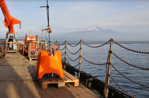
Ocean Bottom Seismometers
For data recording on the seabed, TenzorGEO uses a fleet of Ocean Bottom Seismometers (OBSs) produced by the top European manufacturer – K.U.M. Umwelt- und Meerestechnik Kiel GmbH. The OBS’s full titanium cylindrical pressure tubes are able to operate at depths of up to 6000m. They include a reliable levelling gimbal that operates ates over a 45° range and delivers excellent results with exceptional dynamic range and low noise floor.
The internal setup of the OBSs consists of the state of the art, ultra-low power, broadband seismometers; a hydrophone and a data logger created by world leading specialists. The seismometer utilised in the OBS has a frequency range between 0.008Hz and 200 Hz. The hydrophone has a frequency range from 0.01Hz up to 100 Hz. The data logger has four channels and a sampling rate of up to 4000 samples per second.
Prior to the deployment of the OBS systems, a carefully modelled deployment grid is created. The deployment grid will be customised for each project depending on the depth of the target, the projected reservoir size and the objectives of the survey (exploration, appraisal or development and production).
Once the required grid is established, the pre-mobilisation stage can commence. The OBSs are assembled, tested, calibrated, sealed and loaded onto sea baskets on a specialised vessel. For offshore operation, the vessel should have the following minimal configuration (subject to the investigation area size):
- Underwater positioning and navigation system (e.g. HiPAP system, HPR series)
- 5 tonne crane
- Deck space for the sea baskets
- Deck space for the TenzorGEO 20 ft working container
- Deck space for the ROV container (if the vessel is not equipped with ROV)
- 5 berths for TenzorGEO staff
Before deployment, pressure tubes are positioned inside the OBSs and are tested and time synchronised via GPS. Deployment is performed in free fall manner and a set of deployed OBSs are left to record the data at the seabed for a minimum of 14 hours. Depending on the size of the survey field, a set of OBSs might be relocated by the Robot Operated Vehicle (ROV) to a new set of positions for further recordings. After all recordings are completed, the ROV attaches a crane hook to an OBS handle and the OBS is recovered by the crane to the deck where the data is recovered and tested.
Ocean Bottom Cables
As the world continues to innovate and advance its technological capabilities, TenzorGEO is constantly observing the changes and strives to ensure our technology can support new endeavours. One particular advancement is the rise of Carbon Capture and Storage (CCS) operations, the process of capturing harmful CO₂ emissions from the atmosphere and their subsequent storage in secure subsurface sites. These operations are spread over a very long period, unlike hydraulic fracturing monitoring where the injection is carried out for a limited amount of time. CCS sites require a permanent, passive and long-term monitoring system to continuously monitor the reservoir and provide real-time alerts to the operator in case of any leakage occurring or the integrity of the storage site being compromised.
Based on the above, TenzorGEO has sought to develop a new method of monitoring these operations to best meet the needs of our clients. Currently in the development stages, our innovative technique utilises Ocean Bottom Cables (OBCs) combined with both our Full-Wave Location and Low Seismic Frequency technologies and provides the operator with all the tools necessary to ensure the safe and efficient delivery of CCS projects.
OBCs are already widely used throughout the world, particularly in the telecommunication and energy industries. In terms of seismic acquisition application, OBCs can be used alongside an assembly of geophones and hydrophones all connected via electrical cabling/fibre optics.
The correct deployment of OBCs is an essential operation. It is best carried out with the use of a vessel that pulls the cables into positioning. Until recently, there were many limitations to this operation, such as not knowing the exact cable positioning after deployment. This procedure now involves the use of expertise software that utilises modern GPS positioning combined with seabed mapping to ensure the cable is positioned in the planned grid design.
Modern software is able to provide 3D models of the cable that accurately displays the cable shape and touch down conditions in real-time. To produce this model accurately the following parameters are considered:
- Cable properties (weight and diameter)
- Forces acting on the cable
- Seabed contours
- Ship manoeuvres
- Ocean current changes
As well as accurate positioning, the tension of the cable is an important factor. If tension is too high the cable will become suspended and poor coupling with the seabed is expected, this can seriously interfere with the ability of the monitoring equipment to detect microseismic activity. To counteract this scenario, a deployment software can provide the vessel and cable engine with instructions to adjust cable payout and vessel navigation to keep the tension within the required limits. Furthermore, control over slack must be addressed. If too much cable is deployed unwanted loops may form as well as economic loss in excess cable use. Again, this is something solved with the use of deployment software.
As well as the deployment, the OBCs must be trenched into the seabed. This will protect the cable from any damage it may be exposed to on the surface as well as reduce the level of interfering noise. The most common method is known as Jet Trenching which involves the use of a subsea robot operated vehicle. This vehicle exerts high-speed water jets from various pumps to displace the seabed matrix, creating a groove in the seabed in which the cable falls into, becoming quickly buried after. Alternatively, some ROVs can physically create this groove using diggers.
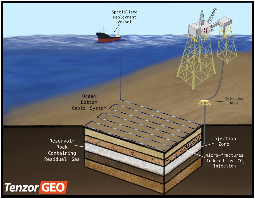
Visual display of Ocean Bottom Cable deployment at location featuring CO₂ injection into the subsurface. The permanent system is positioned above the reservoir to detect micro-seismic events induced by gas injection into the subsurface for the purpose of enhancing hydrocarbon production or ensuring the fluid is behaving as expected from previously developed models.