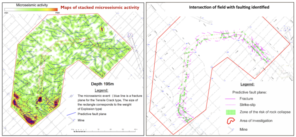
Natural complications associated with rock caving and/or gas-water-steam inflows of various kinds occur regularly during shaft-sinking and tunnelling operations and can necessitate emergency shutdowns. Majority of such complications is caused by disjunctive disturbances and the associated shatter zones (increased fracturing) of the rock.
An early assessment of the position of disjunctive disturbances and decompacted zones in new areas of oil mines prior to the start of the shaft-sinking and tunnelling operations allows for caving prevention measures to be put in place, thereby saving sinking time and reducing the risk of accidents during the construction of mine workings and their subsequent use.
The purpose of the TenzorGEO’s observations was to identify zones of active natural fracturing and determine the azimuth of their direction to predict faults and decompacted zones in the deep interval of mine workings in planned mining operations in order to reduce the risk of caving during mine workings.
The key advantages of the TenzorGEO’s natural fracture monitoring method are: observation from the surface without the need to be in the mine; the ability to observe the entire assessment area, not just the area adjacent to the face, before the start of the shaft-sinking and tunnelling operations.
The key tool for this application is FWL. The main stages of work are: signal processing and filtering, calibration, numerical modelling, restoration of the seismic moment tensor using the maximum likelihood method and event detection.
This is how TenzorGEO can help to address some key mining issues:
1. Use forecast maps (showing accumulated microseismic events and assumed discontinuities along the section closest to the depth of the mine working) to plan and safely perform shaft-sinking and tunnelling operations in the areas of the studied blocks of mines.
2. Pay special attention to the areas of intersection of the shafts of the design mine workings with zones of increased microseismic activity, as the zones of decompaction of rocks and marked prospective ruptures, to minimise the risks of caving.
3. Use forecast maps for sections within the target reservoir at each of the assessment areas to design underground horizontal drilling in the productive reservoir in order to prevent complications and accidents (sticking of drill strings, etc.), or to optimise reservoir development processes (selection directions of horizontal shafts of production mines, optimal locations for steam injection wells, etc.)


